What Is the Strait of Hormuz?
The World’s Most Critical Oil Chokepoint
A narrow 33 km waterway that controls one-fifth of the entire world’s oil supply — and why every government, trader, and energy consumer should understand it.
1. What Is the Strait of Hormuz?
The Strait of Hormuz is a narrow, strategically vital waterway that connects the Persian Gulf to the Gulf of Oman and ultimately the Arabian Sea. It is the only sea passage through which ships can travel from the Persian Gulf to the open ocean, making it one of the single most consequential geographical features in the modern global economy.
The strait takes its name from the ancient port city of Hormuz, once a thriving mercantile hub on the Iranian coast. Today, the strait it lent its name to carries far more commercial weight than that old city ever did — it is, in the words of energy analysts, “the gate” of global petroleum supply.
According to the U.S. Energy Information Administration (EIA), the strait is deep enough and wide enough to accommodate the world’s largest crude oil supertankers. This physical characteristic, combined with its unique geography, makes it both irreplaceable and extraordinarily vulnerable.
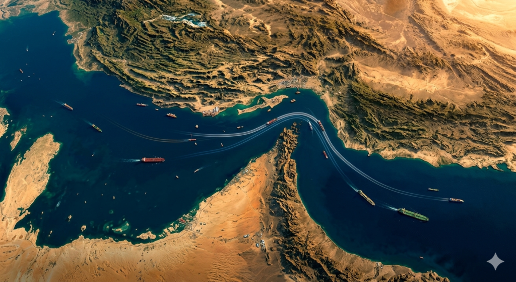
2. Location & Geography
The Strait of Hormuz is located at the mouth of the Persian Gulf, positioned between two landmasses: Iran to the north and the Musandam Peninsula — shared between the United Arab Emirates and the Omani exclave of Musandam — to the south.
The navigable shipping lanes are astonishingly narrow — just 3 kilometres wide in each direction, separated by a 2-nautical-mile buffer zone. Large vessels travelling in opposite directions essentially pass within sight of each other in channels flanked by Iranian territorial waters on one side and Omani waters on the other.
The strait’s deepwater channels run close to the Iranian coastline, a factor of enormous strategic significance. Several islands within the strait — Qeshm, Hormuz, and Hengam — fall under Iranian sovereignty, meaning Iran has physical proximity to virtually every ship that transits the waterway.
3. Why It Matters: Oil & LNG Flows
Understanding the Strait of Hormuz’s importance begins with a single statistic: in 2024, an average of 20 million barrels of oil per day flowed through this passage. That figure, documented by the EIA, represents approximately 20% of all global petroleum liquids consumption and more than one-quarter of total global seaborne oil trade.
To put that in perspective, the entire United States consumes roughly 20 million barrels per day in total. One narrow 33-kilometre waterway moves the equivalent of America’s entire daily oil demand — every single day.
“The Strait of Hormuz is not just an important lane; it is the gate.”
Beyond crude oil, the strait is the world’s most important chokepoint for liquefied natural gas (LNG). According to data from the International Energy Agency (IEA) and the EIA, approximately 20% of global LNG trade transited the Strait of Hormuz in 2024 — primarily from Qatar, the world’s largest LNG exporter. Qatar sends virtually all of its natural gas exports through these waters to customers across Asia and, increasingly, Europe.
| Commodity | Daily Volume (2024–2025) | Share of Global Trade | Key Exporters |
|---|---|---|---|
| Crude Oil & Condensate | ~15–17 million b/d | ~34% of global crude trade | Saudi Arabia, Iraq, UAE, Kuwait |
| Petroleum Products | ~3 million b/d | Significant share of refined trade | Saudi Arabia, UAE, Kuwait |
| Liquefied Natural Gas | ~9–10 Bcf/day | ~20–21% of global LNG trade | Qatar, UAE |
The destination of this oil is largely Asia. According to IEA analysis for 2025, approximately 84% of crude oil and condensate exports through the strait headed to Asian markets. China and India alone received 44% of all Hormuz crude exports combined. Japan and South Korea are also critically dependent on the strait for their energy imports.
4. Which Countries Depend on It?
The Strait of Hormuz is the primary — and in many cases only — export route for seven of the world’s major oil and gas producing nations. A disruption to the strait is not merely a regional inconvenience; it is a global energy emergency.
| Country | Role in Hormuz Trade | Alternative Route Available? |
|---|---|---|
| Saudi Arabia | Largest single exporter through strait (~38% of Hormuz crude flows) | Yes — East-West Pipeline |
| UAE | Major oil exporter, most shipments via Hormuz | Partial — Fujairah Pipeline |
| Iraq | All seaborne oil exports transit Hormuz via Basra | No |
| Kuwait | Entirely dependent on the strait for oil exports | No |
| Qatar | All LNG exports pass through Hormuz | No |
| Iran | Uses the strait but also borders and controls it | Theoretical — Jask Pipeline (not operational) |
| Bahrain | Small exporter fully dependent on the strait | No |
On the importing side, the nations most exposed to a Hormuz disruption are China, India, Japan, and South Korea — together accounting for 69% of all crude oil flowing through the strait. These economies have built their industrial base, power generation, and transport infrastructure around reliable access to Gulf oil. Any prolonged disruption would trigger immediate supply shocks and price spikes in these countries.
5. Are There Bypass Alternatives?
One of the most unsettling truths about the Strait of Hormuz is that no truly adequate alternative exists. Geography prevents another sea route; the only bypass options are land-based pipelines, and their capacity is sharply limited.
The two significant pipeline alternatives are:
Saudi Arabia’s East-West Pipeline (Petroline): This pipeline runs approximately 1,200 kilometres across Saudi Arabia from the Eastern Province oilfields to the Red Sea port of Yanbu. Saudi Aramco reported in March 2025 that it had increased capacity to 7 million barrels per day. However, as of early 2026, only around 2 million b/d of that capacity is actively used, leaving between 3 and 5 million b/d of potential spare capacity — nowhere near sufficient to replace Hormuz flows if the strait were fully blocked.
UAE’s Abu Dhabi Crude Oil Pipeline (ADCOP): This 400-kilometre pipeline runs from oil facilities at Habshan to the Fujairah terminal on the Gulf of Oman, effectively bypassing Hormuz. With a capacity of approximately 1.5–1.8 million b/d, this route helps the UAE redirect some exports, but it too falls dramatically short of the 15–20 million b/d that currently transits the strait.
Energy security experts are clear on this point: the difference between pipeline capacity that exists “on paper” and infrastructure that can “fully replace Hormuz” is enormous. Supply chains, refinery configurations, shipping logistics, and contractual obligations all remain calibrated around the strait being open.
6. History of Tensions & Conflicts
The Strait of Hormuz has been at the centre of geopolitical tensions for decades, given that Iran sits on its northern shore and has repeatedly signalled its willingness to use this position as a lever of power. Below is a timeline of key incidents:
- 1984–1988 — The Tanker War During the Iran-Iraq War, both sides attacked oil tankers in the Persian Gulf. The U.S. Navy deployed warships to escort Kuwaiti tankers in what became known as Operation Earnest Will (1987–1988), the largest naval convoy operation since World War II.
- 2007 Iran’s Revolutionary Guards seized 15 British naval personnel near the strait at gunpoint, holding them for 13 days in a high-profile diplomatic standoff.
- 2012 Iran threatened to close the Strait of Hormuz in retaliation for U.S. and European economic sanctions over its nuclear programme, triggering a spike in global oil prices.
- 2019 Four vessels, including two Saudi oil tankers, were attacked off Fujairah just outside the strait. The U.S. blamed Iran; Iran denied involvement. Tensions escalated sharply.
- 2021 An Israeli-managed tanker was attacked off Oman’s coast, attributed to Iranian drone strikes. Iran inaugurated the Goreh-Jask pipeline and Jask terminal — a bypass designed to reduce its own dependence on the strait — but the route never became operational.
- 2023–2024 Iran seized multiple commercial vessels near or within the strait, including the MSC Aries container ship in April 2024 with 25 crew members aboard, claiming maritime law violations.
- 2025 Two tankers collided and caught fire near the strait amid reports of electronic interference. Insurance premiums for transiting the strait rose sharply.
7. The 2026 Crisis: What Is Happening Now
As of March 2026, the Strait of Hormuz is at the centre of a major international military confrontation. Following joint U.S. and Israeli military strikes on Iranian nuclear and military facilities — and the death of Iranian Supreme Leader Ali Khamenei on 28 February 2026 — Iran’s Islamic Revolutionary Guard Corps (IRGC) issued warnings prohibiting commercial vessel passage through the strait.
The situation remains fluid and extraordinarily consequential. Iran has indicated it will allow passage for ships from nations it considers neutral or friendly — Turkish ships, Indian-flagged gas carriers, and Saudi tankers bound for India have reportedly been granted safe passage at various points. However, the global shipping community has treated the strait as effectively closed, with profound implications for world energy markets.
The U.S. military has been actively engaged, destroying 16 Iranian minelayers after U.S. intelligence sources reported Iran had begun planting naval mines in the strait. Oil prices and global shipping insurance costs have surged dramatically in response.
8. Global Economic Impact of a Closure
The economic consequences of a prolonged Strait of Hormuz closure would be catastrophic for the global economy. Energy analysts and institutions from the IEA to Goldman Sachs have modelled the scenario — and the numbers are sobering.
According to the IEA’s most recent assessments, the bulk of the world’s spare production capacity resides in Saudi Arabia, and most of that capacity can only reach markets via the Strait of Hormuz. A closure therefore does not merely reduce oil supply — it also neutralises the world’s primary emergency buffer against supply shocks.
The freight market is the clearest real-time barometer of chokepoint risk. When vessel availability tightens or insurers re-price risk, freight and financing costs adjust within days. As one logistics analysis noted, “no other corridor carries a similar share of globally traded oil and LNG relative to world consumption.” When the strait is threatened, there is no parallel infrastructure capable of absorbing the displaced volume.
Even consumer goods beyond energy feel the impact: plastics, fertilisers, aviation fuel, and petrochemical feedstocks all trace supply chains back through Hormuz. Nations that run lean strategic petroleum reserves — a growing number of Asian economies — face acute vulnerability when the strait is disrupted for more than a few weeks.
9. Frequently Asked Questions
Conclusion: The Gate the World Cannot Afford to Lose
The Strait of Hormuz is more than a body of water. It is a 33-kilometre-wide thread on which the entire fabric of modern industrial civilisation has come to depend. One-fifth of the world’s oil, one-fifth of its natural gas trade, and the livelihoods of billions of people — from factory workers in Shenzhen to commuters in Tokyo to farmers in Punjab — are bound up in whether this narrow passage remains open.
The events of 2026 have demonstrated, with brutal clarity, how fragile this dependency truly is. When geopolitical tensions rise around the strait, the entire global economy feels it within days. Oil prices surge. Insurance premiums multiply. Shipping slows. The cascading effects reach every corner of the planet.
Understanding what the Strait of Hormuz is — its geography, its tonnage, its history of conflict, and the breathtaking scale of its importance — is not merely an academic exercise. It is essential knowledge for anyone trying to understand the world economy, energy security, and the geopolitical pressures that shape our era.
“What Is the Strait of Hormuz? The World’s Most Critical Oil Chokepoint Explained (2026)”
🎨 Image Generation Prompt:
“Aerial photorealistic satellite view of the Strait of Hormuz at golden hour, showing the narrow deep-blue waterway between the green-brown coastlines of Iran to the north and Oman/UAE to the south. Multiple large oil supertankers are visible navigating the passage in both directions. Overlay subtle glowing route lines along the shipping lanes. The Persian Gulf is visible on the left, the Gulf of Oman opens to the right. Dramatic cinematic lighting with warm oranges and deep ocean blues. No text overlays.”
Leave a Reply